Rangelands are rich in natural diversity.
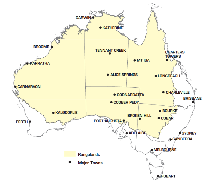
This land type is found worldwide in areas of low rainfall and their features can include grasslands, savannas, woodlands, shrublands and wetlands. More than eighty percent of the Australian continent is classified as rangelands. They are places of significant cultural heritage, and they are where people are increasingly adopting vital land management strategies that are both culturally informed and critically innovative.

Map describing the extent of the rangelands and major population centres.
Innovation in the Rangelands
There are many examples of farms across Australia being managed innovatively, and these are worthy of a closer look;
David and Frances Pollock, Wooleen Station, situated on Wajarri Yamatji land located 700km north-north east of Perth in Western Australia
Jody Brown and family, Latrobe Station, situated on Iningai Country located 50km east of Longreach in Queensland
Cathy and Graham Finlayson, Bokhara Plains, situated on land of the Ngemba, Ualarai, Murrawarri and Wailwan Aboriginal people, approximately 100km east-north east of Bourke in New South Wales
Rangelands Revealed draws on the compelling features of the landscape near Cobar, situated on Ngiyampaa Wangaaypuwan country in western NSW, and the slideshow below contains glimpses of textures, tones, views, and animals of that place.
Hope in Motion
In many ways the title of the music, ‘Hope in Motion‘, which accompanies the slideshow above sums up the work being done daily by land managers working to repair rangelands across Australia and around the world.
Silk thread is bound along the edge of many of the pieces in the Rangelands series, and this element is a metaphor for the mending of land being carried out in the rangelands. Silk is ephemeral and requires gentle handling, just as farmers understand that land requires a combination of Indigenous and critically-informed care through processes broadly referred to as Regenerative Agriculture. The owners of the properties listed above have been contacted in conjunction to this project because a key part of the work they do involves monitoring on-farm actions towards understanding their decisions over time. An example of this kind of record-keeping is a sequence of five images in the slideshow above capturing grazing impact near Cobar throughout 2000 - 2003. This kind of visual record can provide a farmer with a clear understanding for how their management of livestock hinders or enhances cover conditions given prevailing conditions.
This project champions land managers who are using strategies including monitoring to repair the function of the natural environment, along with other strategies towards enhancing the well-being of their community. This project provides ongoing support to this kind of hopeful work through an annual donation to the Adopt an Acre program at Wooleen Station in Western Australia.


